The US military is scrambling to recover an expensive spy blimp that broke loose from its moorings and is threatening air traffic north of Baltimore, Maryland. Fighter jets are shadowing the helium-filled balloon as it drifts over Pennsylvania.
According to the US Army’s North American Aerospace Defense Command
(NORAD), the runaway blimp was first reported at an altitude of about
16,000 feet (4.8 km). It is trailing 6,700 feet (2 km) of cable below,
posing a navigational hazard to aircraft.
The article was carried on RT News with nary a wimper. Question, when
was the last time you heard in the controlled major mass media about
“Spy Satellites” Answer, almost never or none. This was confirmation
that high platform communications and surveillance technology has been
deployed on a large scale. At 100,000 ft try finding a white or stealth
designed 50-100ft blimp. That would be like trying to find a
nano-particle in a bowl of soup. With cloud and geoengineering cover
obscuring more they’re essentially invisible. Continue Reading
And to top it off here’s a recent article about the TARS program that has been deployed over the eastern seaboard.

Though halted by the US Department of Homeland Security in February of 2013, on 1/26/2014, the Washington Post reported that the TARS system has been, in essence, reactivated as
a test program designed to scan an area in radius spanning from North
Carolina northwards to Boston and extending as far west as Lake Erie, in
order to offer greater radar protection. Of even greater interest was
the fact that the epicenter of the new surveillance dirigible program
will focus on Washington, DC, which already utilizes what could easily
be described as the most exhaustive radar net in North America, if not
the world.
TARS, which stands for “Tethered Aerostat Systems,” utilizes radar
equipped dirigibles in order to detect low-flying aircraft ostensibly
seeking to evade the US air radar net along Mexico’s border. The system
originally provided high resolution radar coverage over the US border
while extending its range into Mexico, the Florida straits, and even a
section of the Caribbean Sea, while also providing drug-trafficking
surveillance for the US DOD counter-drug programs. In addition, TARS was
considered a segment of protection for the North American Aerospace
Defense Command with regard to their air sovereignty missions for the
continental US.
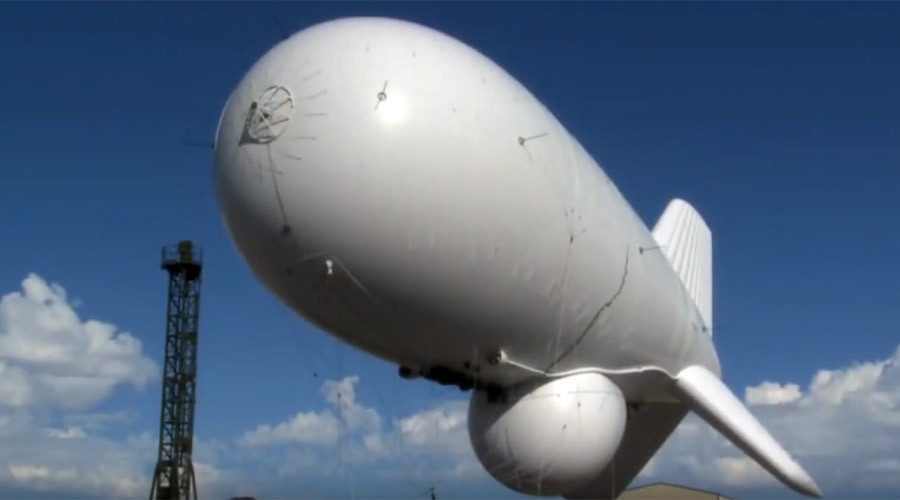
The TARS dirigible
The discontinued TARS anti-incursion program was designed to be extraordinarily low-cost and had been in service since the early 1980’s, run largely by private contractors under government supervision. Despite increasing concerns over terrorists’ ability to use the porous border as a means to create havoc, especially in the air, the TARS program was said to have been of low priority, too expensive at about $ 3.5 million, and even technologically irrelevant in the modern day, which were all reasons being offered in 2013, for the program’s discontinuance.
TARS to JLENS
The newly announced three year test, which is being run by the US military, will tether a starting team of two dirigibles, set at an altitude of about 10,000 feet, over the Aberdeen proving Ground, which is an Army base located in Maryland. JLENS, visually, a startling similar platform as compared to TARS, except at about $2.5 billion dollars more The base is only about 45 miles north of Washington DC. The stated goal of these dirigibles will be to detect cruise missiles launched from somewhere off the East Coast, a long-held problem apparently, which is only now being unveiled as a valid concern, at least in some upper-level circles.
However, many believe the updated program which will be identified under the acronym JLENS (Joint Land Attack Cruise Missile Defense Elevated Netted Sensor System) may have another use altogether, which centers on extraordinarily unique surveillance capabilities centered along one of the most populous corridors in the entire US.
The US Army’s PTDS system
These same aerostat systems were used to great effect over both Iraq and Afghanistan while using state of the art surveillance systems powerful enough to detect movements of both insurgents and US soldiers, individually.
A Higher Perch
Despite the Army’s recent statements of “no plans” for surveillance cameras, the system has already been touted as having the ability to detect and radar track cars, trains, and even boats, however, the system has been stated to have no actual capability of tracking individuals, despite the use of the word LENS being omnipresent within the acronym.
Experts offering a defense of the program, indicate that the high angle of view for these types of heightened surveillance systems severely limit such system’s capability to detect a face or a license plate. This despite the fact that a JLENS system over Kandahar positively identified the images of recently convicted Sgt. Robert Bales, returning to his base during the night after murdering numerous Afghan civilians in their sleep.
The dirigible, long a mainstay of dystopian science fiction novels, may become a permanent part of the US urban skyscape, at least if government designs are maintained. Indeed, the other questions of such surveillance systems over the US, center on the extraordinary abuses still being discovered concerning NSA eavesdropping on US citizens, and drones being used to strike civilians. In March of 2013, Conservative Sen. Rand Paul, supported by the ACLU and other Liberal groups, instituted a US Senate filibuster designed to force the Obama Regime and Attorney General Eric Holder, to answer the question of whether or not drones might be used by the US government to strike US citizens.
The US military, under direction by the White House, has plans for at least 16 surveillance systems such as the one being test deployed over the nation’s capital. However, the possibility of an aerostat system theoretically being used to direct drone strikes can’t be dismissed, as the US continually seems to be more and more directing its security systems inward towards its own civilians, while previously stating that the same system along the US-Mexico border was both too expensive and largely outmoded by modern technology.
Strategically, while the US East coast might be construed as vulnerable to cruise missile attacks, the JLENS system’s first deployment might beg the question of why the East Coast? The US Pacific Coast appears far more vulnerable to attack by certain increasingly hostile Pacific powers, which are significantly more likely to use the Pacific Ocean as an attack approach to the US, rather than the Atlantic.
The JLENS development cost, currently pegged at $2.7 Billion for 2 systems, is far higher than the discontinued TARS program with its cost of about $ 3.5 million annually, despite being described as using essentially the same technology. (source)
The Occult Roots Of NASA And The Ongoing Fraud: Part 3: Space Does Not Exist!
How Do Satellites Survive 4,000F + Degree Heat in Space?
Did We Go to the Moon? The Van Allen Belt Mystery
The Hubble Telescope Hoax
How Can NASA Measure Stars a Hundred Million Quadrillion Miles Away?
How Did Apollo Moonwalkers Survive 200 F + Temps?
How Did Gemini and Apollo Crews Not Break Their Backs on Splashdown?
Why Was NASA Created?
Do These Look like Satellites to You?


No comments:
Post a Comment